The MoRPh Rivers field survey was originally designed as an accessible science-based standard method for use by citizen scientists and non-profit organizations. It now forms one component of a suite of tools developed for assessing the condition of rivers, streams and canals as part of the Watercourse Unit Module within The Statutory Biodiversity Metric and the calculation of Biodiversity Net Gain.
What is the difference between MoRPh CSci and MoRPh Pro?
MoRPh Citizen Science training provides a user-friendly method for volunteers and researchers to gather evidence and build understanding of changes in the physical habitats of rivers and streams. The MoRPh CSci method generates a basic set of 14 indicators for individual MoRPh survey modules and MoRPh10 subreaches comprising 10x side by side MoRPh modules. All approved Citizen Science data are shared via the open source MoRPh Citizen Science Map and also available to Catchment Partnerships via the Catchment Based Approach CaBA Data Hub.
MoRPh Pro and River Condition Assessment (RCA) training combines the user-friendly MoRPh field survey with a geomorphological River Type desk study to generate and help interpret a detailed set of 37 MoRPh Pro indicators and raw data from individual modules and MoRPh5 subreaches, are securely saved in a private workspace. The River Condition Assessment standard method and training provides environmental professionals with the foundation knowledge plus software tools to enable a baseline assessment of River Condition together with scenario modelling options for forecasting target condition, as needed for Biodiversity Metric assessment and Biodiversity Net Gain reporting.
A River Condition Assessment & Encroachment Reporting Sheet is available as an editable resource to all RCA delegates and on request. The RCA Reporting Sheet has been designed to support discussions and decision making; and to align with GOV.UK Statutory Biodiversity Metric Condition Assessments and Natural England’s Habitat Management and Monitoring Plan template
MoRPh Pro and the RCA method can also be used for other types of professional applications, including baseline and post-intervention investigations or forecasts. For example, for river improvement opportunity mapping, river restoration or natural flood management (NFM) baseline and post project appraisals and monitoring physical habitat responses to change associated with artificial interventions or natural processes.
In early 2024, the Guide to Assessing River Condition and RCA training were updated in readiness for the launch of the Statutory Metric. Updates to the RCA guidance are captured in a change log, notably they include adjustments to Condition Class threshold values based upon detailed investigations and new evidence for RCA on canals, navigable rivers and large rivers (see Table 3 p.16) to take account of the findings for these types of watercourses. You can find out more about these changes in Canals, Navigable Rivers and Large Rivers: Changes made to RCA Computations from 2024 and their Rationale.
For more details and to book a place on the next available course, please click below.
River Condition Assessment Tools
The figure below outlines the structure of the standard River Condition Assessment methodology. The individual components are discussed below:
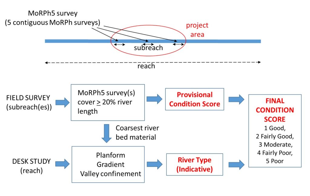
1. MoRPh Field Survey
A basic MoRPh Rivers field survey that characterises the local physical structure of a river channel and its margins. The MoRPh field survey is typically conducted over a river length of 10 to 50 m.
2. MoRPh5
A sequence of 5 adjacent or contiguous MoRPh field surveys (typically 50 to 250 m in length) that draws upon the recorded field data to calculate over 30 indicators that contribute to a preliminary condition score for the MoRPh5 subreach to provide an indicative value for longer lengths displaying consistent character and condition.
3. River Type Survey
A desk-based reach-scale (1 to 5 km) study identifies the hydro-geomorphological river type for the length of river being assessed. The determined River Type translates the preliminary condition score for each MoRPh5 subreach into a final river condition class, which reflects the baseline and together with wider contextual information and professional knowledge, helps to inform what is achievable for that river type.